The paper, and naming your environment
What counts as a large natural environment
- A large natural environment is a distinctive part of the Earth's surface defined by its common natural characteristics. The word doing the work is common — the whole area has to share something.
- Scale is specified: national, regional or continental. A single beach, one waterfall or a paddock is too small. A whole mountain range, a river basin, a desert or a stretch of coast is right.
- It may be in New Zealand or overseas. The standard says so and the paper's instruction page repeats it, so an overseas environment is never a risk.
- Natural does not mean untouched. Almost every large natural environment on Earth has dams, farms, roads or towns in it. Aspect 4 of this standard is how people interact with the environment, so the people are part of the assessment, not a problem with your choice.
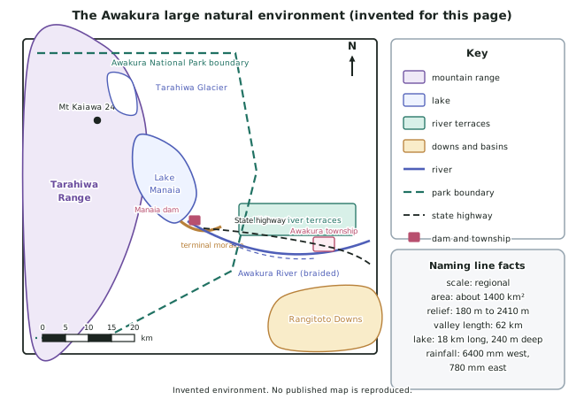
- A worked example of a valid choice, invented for this page: the Awakura environment — about 1,400 km2 of glaciated valley and range in the invented South Island interior, running from the Tarahiwa Range in the west to the Rangitoto Downs in the east, with a relief range of 180 m to 2,410 m.
How the paper is built
- ONE question, no choice, all parts compulsory. This is true of every Geography external at both levels, so there is no exam strategy about which question to pick.
- Whether the question is divided varies by year. 2023 and 2025 were a single undivided question; 2022 and 2024 had parts (a) and (b). Do not walk in expecting one shape.
- The instruction page always asks you to name the environment first, and confirms it may be in New Zealand or overseas at national, regional or continental scale.
- The instructions also require three things in your answer: case study evidence, geographic terminology, and geographic concepts integrated into what you write.
- 2025 added a printed definition of process to the instructions, alongside the box of concept definitions. The definitions being supplied means you are marked on using them, not on recalling them.
- 2024 and 2025 explicitly invite diagrams and maps in the answer. A labelled sketch map or cross-section is not decoration here — it is a fast way to deliver evidence that would take a paragraph in words.
The naming line, and why it is worth marks
- Almost every stem opens the same way: Name ONE [characteristic / element / group], then explain how and why… The naming comes first, the explanation after.
- Name from the closed list. When the question asks for a natural characteristic, the answer must be a landform, a climate feature, a soil or a vegetation type. Nothing else is a natural characteristic in this standard.
- A name is not a sentence. Write the specific thing: not mountains but the Tarahiwa Range, rising to Mt Kaiawa at 2,410 m.
- Locate what you name. Absolute location (a grid reference, a distance and direction) or relative location (at the head of the valley, 62 km inland) both work, and both are geographic terminology being used correctly.
- Then answer the verb. If the stem says explain how and why, two things are being marked — the mechanism (how) and the reason (why) — and students routinely answer only the first.
Case study evidence, and what makes it count
- Evidence means specifics from your environment: named features, figures, dates, rates, areas and distances. It is the difference between the three grades more than anything else you do.
- Supporting evidence (Achieved) is a specific fact attached to a correct explanation.
- Detailed evidence (Merit) is quantified and located: not it rains a lot in the west but 6,400 mm a year at the divide against 780 mm on the Rangitoto Downs, 48 km east.
- Integrated comprehensive evidence (Excellence) is evidence that carries the argument rather than following it. The figure appears inside the sentence that makes the point, and the same evidence is used again later to link a second aspect.
- Build an evidence sheet while you revise, one line per fact, and learn about twenty figures. Twenty is enough for any question this paper asks.
The grade ladder in this standard
- Achieved — explain the aspect with supporting evidence. A correct mechanism and a specific fact.
- Merit — explain in detail, which the standard's own wording glosses as convincingly: reasoned and clear, with detailed evidence. Detail means figures, sequence and named places, not more sentences.
- Excellence — fully explain, using geographic terminology and concepts, showing insight, with integrated comprehensive evidence. The standard's word is perceptively: insightful and/or original.
- Insight in this standard almost always means a link. Between two aspects, between two elements, or between a process and a decision people made. A page of correct description is Achieved however long it is.
Worked Example
Worked example
A student is given this stem, written in the shape the paper uses:
Name ONE natural characteristic of a large natural environment you have studied. Explain how and why this characteristic is distinctive.
Here are their first two attempts. Diagnose each one, then write the version that reaches Merit.
- Attempt 1: The environment has big mountains. They are distinctive because they are very high and it rains a lot there.
- Attempt 2: The Tarahiwa Range is a landform. It is distinctive because of its height and its climate.
Answer:
Step 1 — check the naming line in each attempt.
Attempt 1 names nothing. Big mountains is a category, not a feature, and no environment is identified. Attempt 2 names a real feature and correctly identifies it as a landform, which is on the closed list. Attempt 2 has the naming line; attempt 1 does not.
Step 2 — check the verb.
The stem asks how and why. Attempt 1 answers neither — very high and rains a lot are descriptions, not mechanisms. Attempt 2 gestures at two things but explains neither, and climate is a second characteristic being borrowed rather than an explanation.
Step 3 — check the evidence.
Neither attempt contains a single figure, date or distance. Both are below Achieved on evidence, whatever else they do.
Step 4 — write the Merit version, with the naming line first, both verbs answered, and quantified evidence.
The Tarahiwa Range is the dominant landform of the Awakura environment, running 62 km north to south along its western edge and rising to Mt Kaiawa at 2,410 m from a valley floor at 180 m.
It is distinctive because of how it was made: the range sits on the Awakura Fault, which is uplifting the schist at about 7 mm a year, and that uplift is fast enough to outrun erosion, so the slopes stay steep rather than wearing down to rounded hills.
It is distinctive why it matters to the rest of the environment: a 2,410 m barrier standing across the prevailing westerly airflow forces the air to rise, which is what produces 6,400 mm of rain a year at the divide against 780 mm on the Rangitoto Downs 48 km east. The landform is the reason the climate is what it is.