How elements and processes interact
What the standard means by interaction
- Interaction is aspect 2 of the five, and the stem shape is explain how the elements and processes of the environment interact.
- Interaction means one thing affects another and the effect can be traced. Two things sitting in the same valley are not interacting; two things where a change in one produces a change in the other are.
- You can interact element with element (relief and climate), process with process (freeze-thaw supplying material for a debris flow), or process with element (uplift building relief).
- Every interaction needs a direction. Write it as an arrow in your plan: relief → climate, not relief and climate.
- The evidence for an interaction is the figure at each end of the arrow. 2,410 m at one end, 6,400 mm at the other, and a mechanism in between.
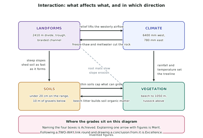
The one-way links, and the figures that prove them
- Landforms → climate. The 2,410 m Tarahiwa Range lifts the moist westerly airflow, producing 6,400 mm a year at the divide and, after descent and warming, 780 mm on the Rangitoto Downs 48 km east.
- Climate → vegetation. Temperature falling at about 0.6 °C per 100 m fixes the silver beech treeline at 1,050 m; the 780 mm total in the east is below what beech needs, so the downs carry browntop and tussock instead.
- Climate → landforms. Freeze-thaw above 1,600 m shatters the schist, and snowmelt gives the river the discharge to move the debris away as bedload.
- Landforms → soils. Slopes above 45° on the trough walls shed soil as fast as it forms, holding steepland soils under 20 cm, while the floor accumulates over 10 m of gravels.
- Vegetation → soils. Beech litter is the only significant source of organic matter on the western slopes, so where the forest is, the soil has a topsoil.
The two-way links, and why they are worth more
- A one-way link can be written after the event. A two-way link makes a prediction, which is why examiners treat it as insight.
- Vegetation ↔ soils. Thin soils cap what can grow on the range front; the vegetation that does grow builds the soil back with litter. Remove the vegetation and the soil thins, which further limits regrowth.
- Vegetation ↔ landforms. Root mats slow slope erosion; steep slopes shed the soil the roots need. Where the 1860s burning stripped the eastern cover, slips increased.
- Feedback has a direction of its own. A loop that amplifies a change is positive feedback (soil loss → less growth → more soil loss). A loop that damps it is negative feedback.
- Name the feedback if you can see it. That is geographic terminology used correctly, which is an explicit Excellence requirement in this standard.
Building the answer from the diagram
- Naming the four boxes is Achieved. Landforms, climate, soils, vegetation, each with a figure.
- Explaining one arrow with figures at both ends and a mechanism between them is Merit.
- Following a two-way link round and drawing a conclusion from it is Excellence.
- Choose one strong arrow rather than six weak ones. A question about interaction is not a question about how many links you can list.
- Sketch the diagram in the answer booklet. 2024 and 2025 invited diagrams, and four labelled boxes with arrows takes ninety seconds and delivers the structure of the whole answer.
Concepts that fit interaction naturally
- Environments — the interactions are what makes it one environment rather than four adjacent things.
- Sustainability — a positive feedback loop is by definition not self-sustaining, and saying so applies the concept rather than defining it.
- Change — interaction explains why a change in one element propagates rather than staying put.
- Processes — the 2025 paper printed the definition, so use the word precisely: sequence, mechanism, result.
Worked Example
Worked example
Explain how the elements and processes of a large natural environment you have studied interact. Support your answer with detailed evidence.
Answer:
Step 1 — pick one chain and one loop, rather than trying to cover everything. The chain earns the detail marks; the loop earns the insight.
Step 2 — the chain, with a figure at every joint.
Uplift on the Awakura Fault at about 7 mm a year has raised the Tarahiwa Range to 2,410 m. That relief stands across the prevailing westerly airflow, forcing it to rise, cool and condense: 6,400 mm of rain a year at the divide against 780 mm on the Rangitoto Downs, 48 km east. That rainfall gradient sets the vegetation — silver beech forest to the 1,050 m treeline in the wet west, browntop and tussock on the dry east. And the vegetation plus the slope sets the soils: under 20 cm of steepland soil where 6,400 mm of rain runs off slopes above 45°, and yellow-brown earths on loess where 780 mm falls on slopes under 5°.
Step 3 — state what the chain shows, so it is an explanation and not a list.
One tectonic process therefore accounts for the pattern of all four natural characteristics. The characteristics are not four independent facts about Awakura; they are four consequences of the same uplift.
Step 4 — the loop, which is where the answer stops being a chain.
But the arrows do not all run one way. Beech litter builds the organic matter in the western soils, and those same thin soils cap what the forest can grow. Root mats slow slope erosion, and the slopes shed the soil those roots need. This is a positive feedback loop: lose the vegetation and the soil thins, and thinner soil supports less vegetation.
Step 5 — test the loop against evidence, because a prediction that survives a test is worth more than one that is only stated.
The eastern downs were burnt in the 1860s for merino grazing. If the loop is real, that ground should not have recovered, and it has not: 160 years later it still carries browntop and tussock, not the beech that its temperature alone would allow.