How the environment is formed and changes over time
What this aspect asks
- Aspect 3 is how the environment is formed and changes over time, and it has appeared as a stem in its own right. It is the only aspect that is explicitly about time.
- Formed means the sequence that produced the environment you see. Changes over time means what is still happening, and both halves must be answered.
- Divide the story into stages, and date each one. A stage without a date is a story; a stage with a date is evidence.
- Rates differ enormously between stages, and the difference is often the most interesting thing you can say.
- Change did not stop. An answer that ends 14,000 years ago has answered formed and ignored changes over time.
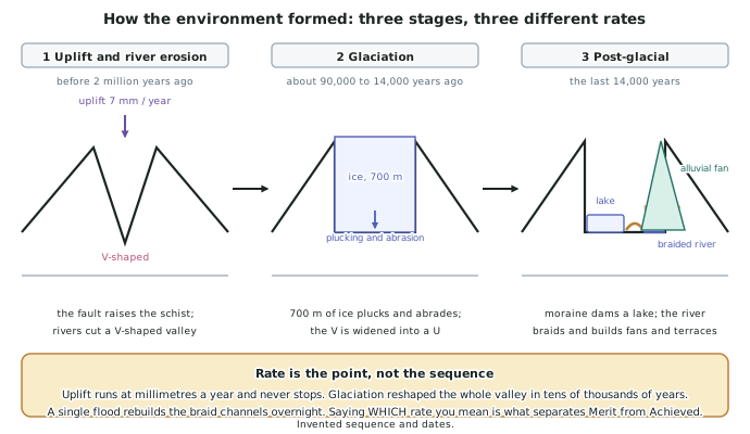
Stage 1 — uplift and river erosion, before about 2 million years ago
- Uplift on the Awakura Fault raised the schist basement at about 7 mm a year, building relief where there had been low country.
- Rivers responded immediately. A river cuts down towards its base level, and raising the land increases the gradient, which increases the river's energy.
- The result was a V-shaped valley. A river erodes along a narrow channel, so the valley it cuts is narrow at the base with slopes retreating above it.
- This stage sets the template for everything after it. The later ice followed the valley the river had already cut, which is why the trough runs where it does.
- The rate to quote is the uplift rate, because it is the only one that has continued through all three stages. The fault is still moving.
Stage 2 — glaciation, about 90,000 to 14,000 years ago
- Global cooling lowered the snowline below the level of the newly raised divide, so snow accumulated faster than it melted.
- Compacted snow became ice about 700 m thick, filling the valley from wall to wall.
- A glacier erodes differently from a river. It occupies the whole cross-section, so plucking and abrasion attack the floor and both walls at once.
- The V was widened and deepened into a U-shaped trough, with a flat floor and walls steeper than 45°, and the floor was overdeepened below the level of its own outlet.
- Everything removed was carried to the snout and dumped there as a terminal moraine when the ice front stopped advancing.
- This is the fastest of the three stages in terms of material moved, which is why glaciated environments look so different from unglaciated ones next door.
Stage 3 — the post-glacial period, the last 14,000 years
- Warming melted the ice back, leaving the trough empty and the moraine in place across it.
- Meltwater filled the overdeepened basin behind the moraine, forming Lake Manaia — 18 km long and 240 m deep.
- The river re-established itself on a valley floor covered in glacial debris. With far more sediment than a modern flow can carry, it braids, splitting and rejoining across a gravel bed.
- Alluvial fans built out where side streams met the trough wall, and the Pikitea river terraces were cut as the river repeatedly incised and then aggraded.
- Change is ongoing and observable. The Tarahiwa Glacier has retreated 2.4 km since 1978, the lake is losing volume to a delta at its head, and the moraine dam is slowly being cut by the outlet.
Writing about time so it earns marks
- Sequence, then rate, then evidence. Say what happened, how fast, and how you know.
- Distinguish the three timescales explicitly: millions of years for uplift, tens of thousands for glaciation, decades for glacier retreat and delta growth.
- Use the word cyclical where it applies. Glacial and interglacial periods have repeated many times; Awakura's trough records the most recent advance, not the only one.
- Present-day change is the easiest evidence to make specific because it has dates you can quote: 2.4 km of retreat since 1978 is worth more than the glacier is melting.
- Landforms are stages, not states. Lake Manaia exists in a window between the erosion that made the basin and the erosion that will eventually drain it, and saying so is insight.
Worked Example
Worked example
Explain how a large natural environment you have studied was formed, and how it continues to change.
Answer:
Step 1 — set out the stages before explaining any of them, so the reader can see the shape of the answer.
The Awakura environment formed in three stages: fault uplift and river erosion before about 2 million years ago, glaciation between roughly 90,000 and 14,000 years ago, and post-glacial reworking over the last 14,000 years.
Step 2 — stage 1, with the mechanism.
Uplift on the Awakura Fault at about 7 mm a year raised the schist. Raising the land steepened the river gradients, which increased their energy, and the rivers cut down into the rising block to produce a V-shaped valley — narrow at the base, because a river only erodes along its channel.
Step 3 — stage 2, and say why the shape changed.
Global cooling then dropped the snowline below the divide. Snow accumulated, compacted, and became a glacier about 700 m thick. Unlike a river, ice fills the whole cross-section, so plucking and abrasion attacked the floor and both walls together. Between roughly 90,000 and 14,000 years ago this converted the V into a U-shaped trough and overdeepened the floor. Material carried to the ice front was deposited there as a terminal moraine.
Step 4 — stage 3, which answers the second half of the question.
As the ice melted back from about 14,000 years ago, meltwater filled the overdeepened basin behind the moraine to form Lake Manaia, 18 km long and 240 m deep. The river, faced with far more glacial debris than it can carry, braids across the trough floor, and it has built alluvial fans and cut the Pikitea terraces.
Step 5 — bring the change up to the present with dated evidence.
Change has not stopped. The Tarahiwa Glacier has retreated 2.4 km since 1978, exposing bare rock that is now being colonised. The lake is filling from its head as every flood adds bedload to a growing delta, and draining slowly as the outlet cuts the moraine.
Step 6 — draw the comparison of rates, which is what lifts the answer.
The three stages operate at completely different speeds: uplift at millimetres a year over millions of years, glacial carving over tens of thousands, and glacier retreat measurable in kilometres per decade. The environment therefore looks stable at human timescales while being, in geological terms, in the middle of rapid change.