The four natural characteristics
The closed list, and why it is closed
- The paper prints four natural characteristics and only four: landforms (relief), climate, soils, vegetation. They are also called the elements of the environment.
- Anything not on the list is not a natural characteristic here. Wildlife, scenery, rivers-as-resources, tourism and weather on the day are all real geography and all wrong answers to name ONE natural characteristic.
- Rivers are a borderline case worth settling now. A river channel is a landform; the water in it is part of the climatic system. Say which one you mean.
- The four are ordered by how quickly they change. Landforms change over thousands of years, soils over centuries, vegetation over decades, climate over a season. That ordering is useful later when the question asks about change over time.
- Each characteristic must be described with a figure and a place, not with an adjective. Steep is not a description. Slopes over 35° on the western rangefront is.
Landforms — describing relief so it earns marks
- Relief means the shape and height of the land surface, and it is described with three numbers: highest point, lowest point, and the difference between them.
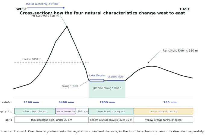
- In the invented Awakura environment, relief runs from 180 m on the eastern valley floor to 2,410 m at Mt Kaiawa — a relief range of 2,230 m across 62 km.
- Name the individual landforms, not just the range. Awakura contains a glacial trough with a U-shaped cross-profile, a terminal moraine damming Lake Manaia (18 km long, 240 m deep), a braided river channel, alluvial fans at the trough wall, and the Pikitea river terraces.
- Describe slope, because slope is what links landforms to everything else. Trough walls above 45° shed soil as fast as it forms; the downs at under 5° hold soil metres deep.
- A cross-section is the fastest way to deliver all of this. 2024 and 2025 invited diagrams; a labelled transect with heights on it is several sentences of evidence in one drawing.
Climate — the gradient, not the average
- A large natural environment rarely has one climate. What is distinctive is usually the gradient across it, so quote both ends and the distance between them.
- Awakura runs from 6,400 mm of rain a year at the divide to 780 mm on the Rangitoto Downs, 48 km east — more than an eightfold difference inside one environment.
- Temperature falls with altitude at roughly 0.6 °C per 100 m. From the 180 m valley floor to the 2,410 m summit that is about 13 °C of difference on the same day.
- Name the airflow that produces the pattern. In Awakura it is the prevailing westerly, moist off the Tasman, forced to rise over the range.
- Give the seasonal figure as well as the annual one if you have it — an environment with 780 mm falling evenly is a different place from one where 780 mm arrives in three months.
Soils and vegetation — the two that respond
- Soil depth is the number to learn. Awakura carries thin steepland soils under 20 cm on the range, over 10 m of recent alluvial gravels on the trough floor, and yellow-brown earths on loess on the downs.
- Soil depth is set by the balance of formation and removal. Steep slopes plus 6,400 mm of rain remove material faster than weathering makes it; flat, dry downs remove almost nothing.
- Vegetation zones are described by their boundaries. In Awakura, silver beech forest occupies the wet western slopes to a treeline at 1,050 m, snow tussock takes over above it, herbfield and bare rock above about 1,600 m, and browntop and tussock dominate the dry east.
- Say what sets each boundary. The 1,050 m treeline is set by temperature; the eastern edge of the forest is set by rainfall; the herbfield boundary is set by snow lie and freeze-thaw.
- Introduced vegetation still counts. Browntop on the eastern downs is a pasture grass, and saying so is a link to aspect 4, how people interact with the environment.
Turning four descriptions into one answer
- A four-paragraph description of four characteristics is Achieved, however long it is and however many figures it carries.
- Merit comes from explaining one characteristic through another — the rainfall gradient explains the vegetation zones, the slope explains the soil depth.
- Excellence comes from the links running both ways — thin soils cap what can grow, and what grows builds the soil back.
- The cross-section diagram is the argument, not the illustration. Read down any vertical line on it and the four characteristics at that spot are all consequences of where that line falls on the range.
Worked Example
Worked example
Using the cross-section above, explain how the soils of a large natural environment you have studied vary across it, and why.
Answer:
Step 1 — read the transect from one end to the other, so the description has a direction rather than being a list.
Moving west to east across Awakura, the soils change three times: thin steepland soils under 20 cm on the trough walls, over 10 m of recent alluvial gravels on the trough floor, and yellow-brown earths developed on loess on the Rangitoto Downs.
Step 2 — give the mechanism for each one before moving on.
On the trough walls, slope exceeds 45° and rainfall reaches 6,400 mm a year. Water moving downslope removes weathered material faster than weathering produces it, so the soil is kept thin — this is erosion outpacing formation.
On the trough floor, the braided Awakura River deposits its bedload during floods. Here material arrives faster than it leaves, so depth builds: over 10 m of gravels, but young and stony, with little organic matter because they are reworked every few decades.
On the downs, slope drops below 5° and rainfall to 780 mm. Almost nothing is removed and almost nothing is added, so a soil has had time to develop horizons in the wind-blown loess — the deepest genuinely developed soil in the environment, on the driest ground.
Step 3 — state the pattern the three cases share, because that is what turns description into explanation.
Soil depth in Awakura is not set by rainfall, and it is not set by slope. It is set by the balance between supply and removal, and rainfall and slope are two of the terms in that balance. That is why the wettest place has the thinnest soil and the driest place has the deepest.