The paper, and choosing your environment
What counts as a geographic environment here
- A geographic environment is the features and characteristics of a specific area. The standard adds one condition that decides everything else: the area must be large enough to allow for the study of several interacting natural processes.
- That condition rules out a single landform. One waterfall, one dune, one cave or one beach cannot show several processes interacting, however well you know it.
- It must be in New Zealand. AS91426 is the only content standard in Geography that names a country, and every year answers arrive describing an overseas environment beautifully and score nothing.
- A good size is a catchment, a coastline, a volcano and its ring plain, or a valley system — big enough for processes to hand material to one another, small enough to name specific places in.
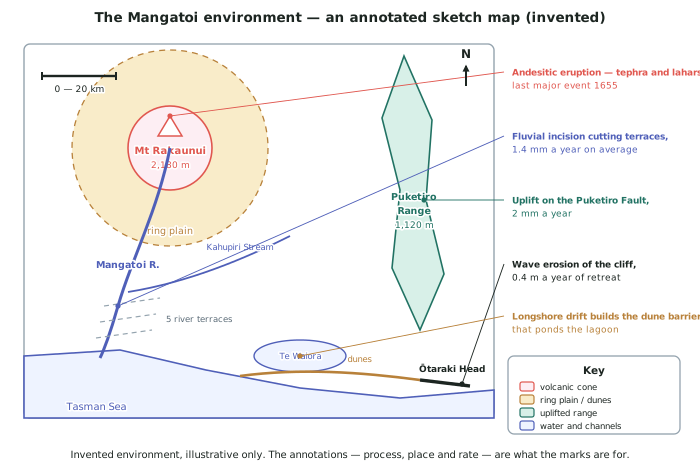
- A worked example of a valid choice, invented for this page: the Mangatoi environment, about 2,000 km2 of an invented western North Island volcano, ring plain, river and coast, running 78 km from the summit of Mt Rakaunui at 2,180 m to the sea at Ōtaraki Head.
How the paper is built
- ONE question, no choice, all parts compulsory. Every Geography external at both levels works this way, so there is no strategy about which question to pick — only about how to divide your time.
- A titled MAP / DIAGRAM page is provided in the answer booklet, and you must use it. Constructing an annotated map or diagram has been required in every paper checked from 2022 to 2025.
- In 2025 the drawing became part (a) in its own right, with the written analysis as part (b) — and part (b) had to be about a second, different feature from the one drawn in part (a).
- The naming box comes first. Before any writing, the paper asks you to name the New Zealand environment and name the interacting natural processes that shape it.
- The paper prints the Excellence wording in the question. Every year the bullet list ends with integrate comprehensive supporting case study evidence, and the definition of insight appears alongside it. You are being told the marking criteria while you write.
- Coloured pencils, a ruler and a calculator are advised equipment, and the specification says annotations must be in pen.
Choosing the processes you will name
- Name processes, not features. The river is a feature. Fluvial erosion, transport and deposition is a process. The naming box wants the second kind.
- Pick processes from at least two different families, because interaction between two river processes is thinner than interaction between a volcanic process and a river process.
- The families you can draw on are volcanic and tectonic (eruption, lahar, uplift, faulting), climatic (rainfall, wind, temperature, freeze-thaw), mass movement (slips, debris flows, slumping), fluvial (erosion, transport, deposition), coastal (wave erosion, longshore drift, dune building) and glacial where the environment has ice.
- In the invented Mangatoi environment the named set is: andesitic eruption and lahars, uplift on the Puketiro Fault at 2 mm a year, orographic rainfall from 4,800 mm to 1,150 mm, mass movement on the cone, fluvial incision at 1.4 mm a year, and wave erosion retreating Ōtaraki Head at 0.4 m a year.
- Three or four processes is enough. More than that and you cannot explain any of them in detail inside the time.
Evidence, and what makes it count at Level 3
- Evidence means specifics from your environment: named features, figures, rates, dates, thicknesses and distances. It separates the three grades more than anything else you do.
- Supporting evidence (Achieved) is a specific fact attached to a correct explanation.
- Detailed evidence (Merit) is quantified and located: not the cliff is eroding but Ōtaraki Head is retreating at 0.4 m a year, about 40 m since 1930.
- Integrated evidence (Excellence) is defined in the standard as examples woven throughout the explanation. The figure sits inside the sentence making the point, and the same figure is used again later to support a different link.
- Build an evidence sheet while you revise — one line per fact, about twenty figures. Twenty is enough for any question this paper asks, and rates are the most useful kind.
Level 2 to Level 3: what actually changed
- AS91240 asked you to explain aspects of an environment. AS91426 asks you to analyse how processes interact — the same material, plus what the parts do to each other.
- Description of four characteristics will not pass here. The verb in the title is about processes shaping an environment, so the answer is built around mechanisms, not around lists.
- The drawing is new. Nothing at Level 2 required a constructed annotated diagram; here it is part of the question.
- The word "interacting" is the whole standard. If your answer would still make sense with the processes described one after another in separate paragraphs, you have not answered it.
Worked Example
Worked example
A student has to fill in the naming box at the top of the paper, which asks for the New Zealand environment and the interacting natural processes that shape it. Here are three attempts. Diagnose each, then write the version that sets the answer up properly.
- Attempt 1: Environment: a waterfall. Processes: erosion.
- Attempt 2: Environment: the Mangatoi River. Processes: the river, the mountain, the sea.
- Attempt 3: Environment: the Mangatoi environment, North Island, NZ. Processes: erosion and deposition.
Answer:
Step 1 — test each environment against the size condition.
The standard requires an area large enough for several interacting natural processes. A waterfall fails immediately. The Mangatoi River is better but still a single feature — a line on a map, not an area. Attempt 3 names an area and locates it in New Zealand, so only attempt 3 passes.
Step 2 — test each list against "processes".
Attempt 2 lists features (the river, the mountain, the sea), not processes. Attempt 1 and attempt 3 name real processes but keep them generic: erosion on its own does not say what is eroding what, or how fast.
Step 3 — check that the processes come from more than one family.
Attempt 3's erosion and deposition are both fluvial. Two processes from one family can only interact in a limited way, which caps the answer before it starts.
Step 4 — write the version that sets the answer up.
Environment: the Mangatoi environment, about 2,000 km2 of the western North Island, from Mt Rakaunui (2,180 m) through its ring plain and the Mangatoi River valley to the coast at Ōtaraki Head.
Interacting natural processes: andesitic volcanic activity (tephra fall and lahars, last major eruption 1655); tectonic uplift on the Puketiro Fault at 2 mm a year; orographic rainfall, from 4,800 mm a year on the cone to 1,150 mm at the coast; fluvial erosion, transport and deposition, incising at about 1.4 mm a year; and coastal wave erosion, retreating Ōtaraki Head at 0.4 m a year.