Interaction: processes operating together
What "interacting" means in this standard
- The standard defines interacting natural processes as processes that operate together to shape the environment. Together is the word that separates this standard from Level 2.
- Two processes operating in the same place are not automatically interacting. They interact when one changes what the other can do — by supplying it with material, giving or taking energy, or changing the surface it acts on.
- There are only three kinds of link you need, and every interaction in any environment is one of them:
- supply — one process gives another the material it works with
- control — one process sets the conditions (slope, cover, water) another depends on
- feedback — the second process changes the first back
- Name the kind of link you are describing. Markers are looking for the connection, and saying this is a feedback makes it impossible to miss.
- A feedback is worth more than a supply link, because it is the kind that lets you draw a conclusion — which is the standard's definition of insight.
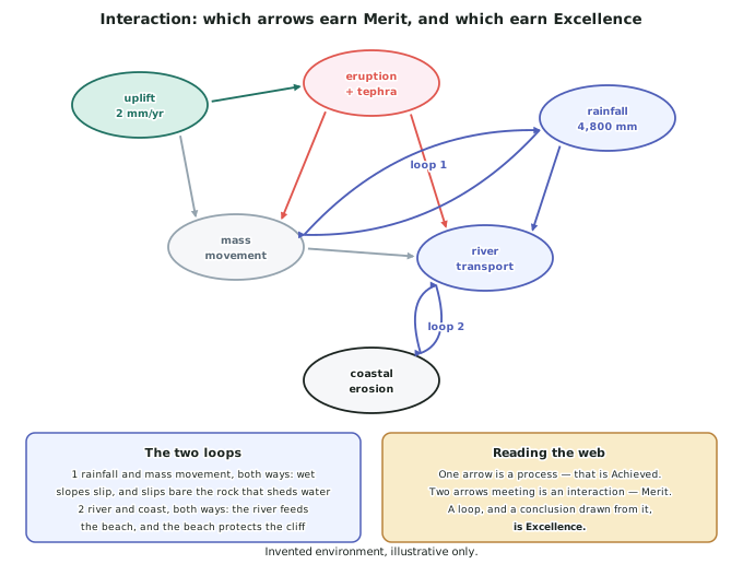
Building an interaction web before you write
- Draw the web in your planning time — three minutes, no more. Put each process in a bubble and join the ones that affect each other.
- Label every arrow with what moves along it. Gravel, water, support, cover. An unlabelled arrow is a guess.
- Then find the loops. Any pair of bubbles with arrows going both ways is a feedback, and those are the paragraphs that reach Excellence.
- In the invented Mangatoi environment there are two obvious loops. Rainfall and mass movement, both ways: wet slopes fail, and each failure bares more tephra, which sheds water faster. River supply and coastal erosion, both ways: the river feeds the beach, and the beach protects the cliff that the sea is cutting.
- Choose two or three links to write about, not eight. A written answer that explains two interactions properly beats one that lists eight.
Writing an interaction paragraph
- Start with the link, not with the processes. The volcano sets the rate at which the river cuts down is a first sentence that promises an interaction. There are volcanoes and rivers in Mangatoi is not.
- Then give both processes their mechanism, briefly — one clause each is enough once you have explained them earlier.
- Then give the evidence that shows the link is real. A rate that changes, a feature that could not exist otherwise, or a place where one process stops when the other does.
- Then say what follows. This is the sentence most answers leave out, and it is where the marks are.
- The four-move shape: link → mechanisms → evidence → consequence. It fits in a paragraph and it works for every interaction you will ever be asked about.
The interactions that carry the invented Mangatoi environment
- Eruption supplies the river. The bedload the Mangatoi uses to cut its channel is volcanic gravel delivered by lahars every 30 years or so — not material the river eroded itself.
- Rainfall controls mass movement. 4,800 mm a year on a 28° slope of bare tephra puts the upper cone at failure; the same rainfall on the 3° ring plain produces nothing.
- The river supplies the coast. Sediment reaching Ōtaraki builds the beach, and the beach's width is what decides whether waves break offshore or against the 40 m cliff.
- The sea supplies the dunes. Longshore drift moving about 60,000 m3 of sand a year built the 12 m barrier that ponds Te Waiora lagoon — a freshwater feature created by a marine process.
- Uplift keeps the whole system running. Uplift at 2 mm a year against incision at 1.4 mm a year means the gradient the surface processes need is being renewed faster than they can flatten it.
What separates the three grades here
- Achieved: the processes are described and their results identified. Correct, specific, and one process per paragraph.
- Merit: the interactions are explained in detail — you say what passes between the processes and support it with figures.
- Excellence: the analysis is insightful, which the standard defines as analysis of the interaction between the processes … to draw conclusions.
- A conclusion is a general statement about the environment that follows from the interactions but is not just a summary of them. The environment's shape is set by how fast material moves between processes, not by any one of them is a conclusion. So the processes all interact is not.
Worked Example
Worked example
Analyse how TWO interacting natural processes have shaped a feature of a New Zealand geographic environment you have studied.
The feature chosen is Te Waiora lagoon, the invented coastal lagoon behind the dune barrier at Ōtaraki. Two attempts are below. Diagnose them, then write the version that reaches Excellence.
- Attempt 1: Te Waiora is a lagoon. Rivers bring water into it and the sea is next to it. Longshore drift moves sand along the coast and dunes form.
- Attempt 2: Longshore drift moved sand along the coast and built a barrier. Behind the barrier, water was trapped and Te Waiora lagoon formed.
Answer:
Step 1 — diagnose attempt 1.
It lists three true statements with no connection between them. Nothing in it explains why there is a lagoon at Ōtaraki rather than an open bay. This is below Achieved on interaction, however accurate each sentence is.
Step 2 — diagnose attempt 2.
This has one link — drift builds a barrier, the barrier traps water — so it is a correct Achieved answer. What it does not say is where the sand came from, why the barrier survives, or why the lagoon has not filled in. One link, no evidence, no conclusion.
Step 3 — identify the processes actually involved.
Four, not two: wave erosion at Ōtaraki Head supplying sediment; longshore drift moving it; fluvial deposition delivering more from inland; and wind building the barrier above high water.
Step 4 — write the Excellence version, using the four-move shape.
The link. Te Waiora exists because two processes that both move sediment along this coast are out of balance with each other, and it will exist only for as long as they stay that way.
The mechanisms. Longshore drift carries about 60,000 m3 of sand a year along the coast, sourced partly from the 0.4 m a year retreat of the 40 m mudstone cliff at Ōtaraki Head and partly from volcanic sediment the Mangatoi River delivers. Onshore westerlies then lift the dried sand above high water and build the barrier to 12 m.
The evidence. The barrier is 6 km long and has kept the lagoon separate from the sea, and the lagoon behind it has not silted up, which tells you the river's sediment is being intercepted by the drift and carried along the coast rather than delivered into the lagoon.
The consequence, and the conclusion. Te Waiora is therefore a freshwater feature maintained by a marine process, and it is conditional. Cut the sediment supply — a smaller cliff retreat, a river carrying less — and the barrier narrows, the sea breaches it, and the lagoon becomes an estuary. The lagoon is not a thing that formed once. It is the visible balance point between two processes, and it records their relative rates.