Rates, scales and variation
Why rates and scales are in this standard
- The standard says the processes may operate at different rates and different scales to create spatial and/or temporal variations. That sentence is scope, not decoration — it tells you what the variations are made of.
- A rate is how fast or how often a process acts. Give it as a distance per year (0.4 m a year), a thickness (18 m of deposit), or a frequency (a lahar every 30 years).
- A scale is how much of the environment one event touches — one slope, one channel, one valley, the whole ring plain, the region.
- Variation comes from the mismatch. Where a fast process acts on something a slow process built, you get temporal variation. Where a local process acts inside a regional one, you get spatial variation.
- This is the most quotable idea in the standard, and it is the fastest way to turn a list of processes into an analysis.
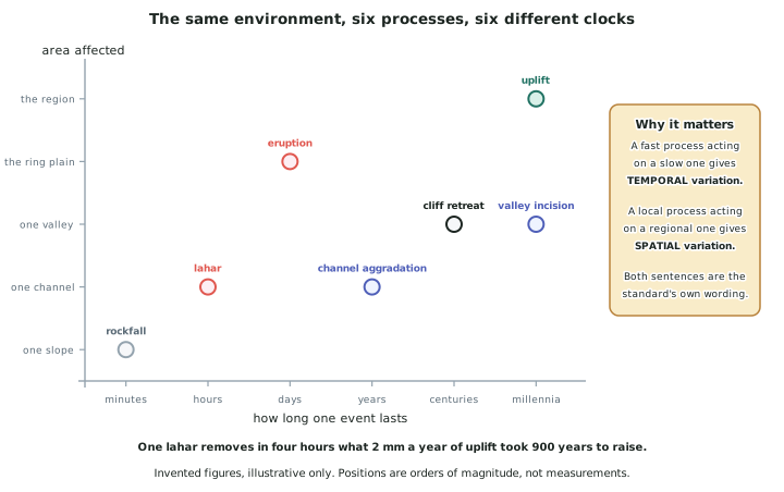
Reading the rates of the invented Mangatoi environment
- Uplift: 2 mm a year, across the region, continuously. Slow, huge, and never stops. Over 25,000 years it adds 50 m.
- Fluvial incision: 1.4 mm a year on average, along the valley. Almost the same speed as uplift, which is why the two must be compared and not just listed.
- Cliff retreat: 0.4 m a year, along 12 km of coast. About 300 times faster than incision, on a much smaller area.
- Lahars: every 30 years or so, hours long, one channel corridor. Between events, nothing; during one, metres of change.
- Eruption: centuries apart, days long, the whole ring plain. The rarest process and the widest reach.
- Say the comparison out loud in the answer. One lahar moves in four hours what 2 mm a year of uplift took 900 years to raise is a single sentence that demonstrates rate, scale and interaction together.
Temporal variation — the same place at different times
- Temporal variation is a recognisable difference in an environment over time, and this standard is interested in the variation processes create, not in random change.
- Look for episodic processes on continuous surfaces. The five river terraces exist because a process that acts in pulses (lahar supply) works on a surface a continuous process (river flow) is always adjusting.
- Use dates and intervals, not "over time". Since 1655, every 30 years, over 25,000 years, about 40 m since 1930.
- Explain the pattern of the variation, not just its existence. The Mangatoi terraces are unevenly spaced, and that unevenness is the evidence that supply has been irregular.
- A temporal variation always has a spatial signature somewhere — the terrace staircase, the tephra layers in a soil pit, the width of the beach. Name it.
Spatial variation — different places at the same time
- Spatial variation is a difference in the same process from one part of the environment to another.
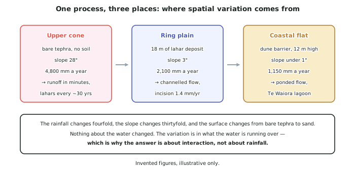
- The strongest way to show it is to hold the process constant and change the place. Water falls on the whole of Mangatoi; it runs off in minutes on the cone, cuts channels on the ring plain, and ponds in Te Waiora on the coastal flat.
- Give the numbers on both sides and the distance between them: 4,800 mm on the summit against 1,150 mm at the coast, 78 km apart; slope 28° against 3° against under 1°.
- Then explain what changes the outcome. In Mangatoi it is not the water that varies but the surface it runs over — bare tephra, then lahar deposit, then sand.
- Spatial variation is almost always the easier one to draw, which matters because you have a MAP / DIAGRAM page to fill.
Using rates and scales to reach Excellence
- A rate on its own is Merit-level detail. Two rates compared, with a consequence drawn, is Excellence-level analysis.
- The comparison that works nearly every time is a fast process against a slow one operating on the same material: uplift against incision, lahar supply against river transport, cliff retreat against beach supply.
- Scale mismatches are just as useful. A regional process (uplift) setting the conditions for a local one (a slip) explains why a local feature exists where it does.
- Finish with the conclusion. The environment's variations are the record of processes running at different speeds having to share the same material is a conclusion the rates support.
Worked Example
Worked example
Analyse how natural processes operating at different rates have created temporal variation in a New Zealand geographic environment you have studied.
Answer:
Step 1 — pick two processes whose rates differ enough to matter, and state them.
Lahar supply delivers material to the Mangatoi valley in pulses — hours long, roughly every 30 years, with far bigger events after each eruption, the last in 1655. Fluvial transport removes material continuously, incising at an average of about 1.4 mm a year over 25,000 years.
Step 2 — say what the mismatch does.
Supply is episodic and removal is steady. That means the river is almost never in balance with its load. For a period after each large supply event it has more material than it can carry, so it deposits and its bed rises; once the supply is used up, the same discharge has spare energy and it cuts down.
Step 3 — identify the feature that records the mismatch.
Each switch from building up to cutting down abandons the surface the river had built. That abandoned surface is a terrace. The Mangatoi valley has five, the highest 42 m above the modern bed.
Step 4 — read the pattern in the record, not just its existence.
The terraces are not evenly spaced. Even spacing would mean supply events of similar size at regular intervals. Uneven spacing means the pulses have varied in size — which is exactly what a volcano that produces small lahars every few decades and a large eruption every few centuries would produce.
Step 5 — draw the conclusion.
The temporal variation in this environment is not caused by any process changing its behaviour. Every process has done the same thing throughout; the variation comes from one of them being episodic and the other continuous. The terrace staircase is therefore not five events — it is one relationship, recorded five times.