Précis maps and map symbols
What a précis map is
- A précis map is a simplified map drawn from a more detailed one, showing only the features you have been asked to show.
- Précis means summary. The skill being marked is selection — deciding what matters — followed by accurate placement.
- It is not a tracing. Copying every road and contour from the resource map wastes time and hides the pattern you were asked to reveal.
- The paper usually gives you a partly drawn outline — a coastline, a valley edge — and asks you to add named features and complete the conventions.
Deciding what to include
- Include exactly what the question names, and the framework needed to locate it. If the question asks for the settlements and the transport routes, draw those, plus the coastline or river that lets a reader place them.
- Leave out everything else. Contours you were not asked for, minor tracks, spot heights and vegetation you do not need make the map slower to draw and harder to read.
- Generalise line features. A road with fourteen small bends is drawn as a smooth line following the same route. Its position must be right; its wiggles need not be.
- Keep the shape of area features recognisable. A lake is simplified but must still be the right shape and in the right place relative to everything else.
Point, line and area symbols
- Symbols come in three kinds, and using the wrong kind is a convention error even if the feature is in the right place.
- Point symbols — a dot, a small square, a triangle — for features that occupy one spot at this scale: a school, a trig station, a wharf, a lookout.
- Line symbols — for features that are long and thin: rivers, roads, railways, tracks, boundaries. Vary thickness or dash pattern, not just colour, so the map still reads if it is photocopied.
- Area symbols — shading or a fill pattern — for features that cover ground: forest, lake, built-up area, farmland.
- Colour by convention where you can: blue for water, green for vegetation, brown for relief, black or red for built features. It is not compulsory, but it makes the map instantly readable.
The key
- Every symbol on the map appears in the key. Nothing in the key is absent from the map. The match must hold in both directions.
- Draw the symbol in the key exactly as it appears on the map — same colour, same thickness, same dash pattern. A key entry that is a different shade is a different symbol.
- Name features on the map itself as well, in small neat writing, where a name is more useful than a symbol. A named river does not need a key entry beyond river.
- Put the key outside the map frame if there is room, or in a boxed corner where it covers nothing.
Title, scale and north arrow
- The title says what and where: Précis map of land use in the Waipuna Valley, not Map.
- The scale is copied or converted from the resource map. A linear scale bar — a marked bar in kilometres — is safest, because it stays correct if the map is enlarged or reduced.
- The north arrow is drawn and labelled N. If the resource map shows north as up, yours should too; rotating a précis map for no reason guarantees errors.
Accuracy: the word that decides Merit
- Merit asks for skills and conventions used to a high level of accuracy. On a précis map, accuracy is about relative position.
- Check three relationships before you finish:
- Is each feature on the correct side of the river, road or coastline?
- Is the order of features along a route the same as on the resource map?
- Are the rough distances between features in proportion?
- A feature drawn on the wrong bank of a river is a substantive error, not a neatness issue — it changes what the map claims.
Worked Example
Worked Example
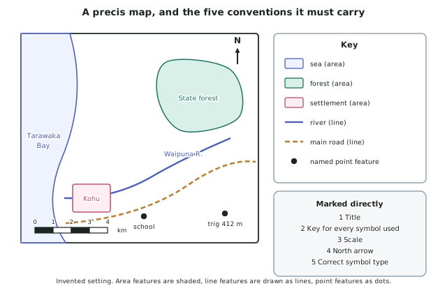
A resource map shows an invented coastal area. You are asked to draw a précis map showing the settlement, the main road, the river and the state forest, with full conventions.
The resource map shows: Tarawaka Bay on the western edge; the Waipuna River flowing from the north-east and reaching the sea; the settlement of Kohu on the southern bank near the river mouth; the main road running from the coast north-east across the river to the forest edge; the state forest in the north-east; a school in the settlement; a trig station at 412 m east of the town; and 40 contour lines.
Draw the map. What is included, what is left out, and what conventions are needed?
Answer:
Step 1 — decide what is in.
The question names four features: settlement, main road, river, state forest. Add the coastline of Tarawaka Bay, because without it nothing can be located. That is five things.
Step 2 — decide what is out.
All 40 contours are out. Relief was not asked for, and drawing it would take longer than everything else combined. The school and the trig station are also not named in the question — but they are cheap to add as point symbols and demonstrate correct symbol use, so include them only if time allows.
Step 3 — choose a symbol type for each.
- Tarawaka Bay — area, blue shading.
- State forest — area, green shading.
- Kohu — area, because a settlement covers ground at this scale.
- Waipuna River — line, blue, drawn as a smooth curve.
- Main road — line, drawn in a different style, such as a dashed brown line, so it cannot be confused with the river.
Step 4 — check the relationships that carry the accuracy mark.
Kohu must sit on the southern bank — putting it north of the river is a substantive error. The road must cross the river, since it runs from the coast to the forest on the far side. The forest must be in the north-east, away from the bay.
Step 5 — add the conventions.
Title: Précis map of Kohu and the Waipuna Valley. Key with one entry per symbol used, drawn in the same colours. Linear scale bar in kilometres, copied from the resource map. North arrow labelled N.
The map, in one line: