Grid references, scale, distance and direction
Eastings and northings
- Topographic maps carry a grid of numbered lines, and every line has a two-figure number printed at the map edge.
- Eastings are the vertical lines. Their numbers increase to the east — to the right.
- Northings are the horizontal lines. Their numbers increase to the north — up the page.
- Always read the easting first, then the northing. The memory phrase is along the corridor, then up the stairs.
- Read from the line below and to the left of the feature, never the nearest line. This is the single commonest error in the whole skill.
Four-figure references name a square
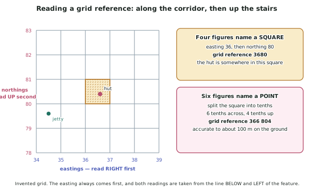
- A four-figure grid reference identifies a whole grid square: two figures for the easting, then two for the northing.
- The square named 3680 is the one whose left edge is easting 36 and whose bottom edge is northing 80.
- A grid square is usually one kilometre across, so a four-figure reference locates something to within about a kilometre — good enough for which square is the lake in, useless for where exactly is the hut.
Six-figure references name a point
- A six-figure grid reference splits each square into tenths and adds one figure to each half.
- Procedure:
- Find the four-figure square containing the feature.
- Estimate how many tenths across the square, from the left edge — that digit goes after the easting.
- Estimate how many tenths up the square, from the bottom edge — that digit goes after the northing.
- Write the six figures together: easting, easting, tenths, then northing, northing, tenths.
- Accuracy: a six-figure reference locates a feature to about 100 metres on the ground.
Scale, written three ways
- Scale states how a distance on the map relates to the same distance on the ground.
- A ratio — 1 : 50 000 — means one unit on the map is 50,000 of the same units on the ground. One centimetre represents 50,000 cm, which is 500 m, or 0.5 km.
- A statement — 1 cm represents 0.5 km — says the same thing in words.
- A linear scale bar — a marked bar in kilometres — is the one to use on your own maps, because it enlarges and reduces with the map.
- Converting a ratio to a statement: divide the second number by 100,000 to get kilometres per centimetre. 1 : 25 000 gives 0.25 km per cm; 1 : 50 000 gives 0.5 km per cm.
Measuring a straight-line distance
- Measure the map distance in centimetres with a ruler, to one decimal place.
- Multiply by the ground distance one centimetre represents.
- State the unit. A number without a unit is not an answer.
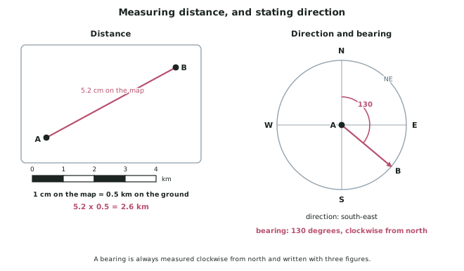
- Worked shape: 5.2 cm on a 1 : 50 000 map is 5.2 x 0.5 = 2.6 km.
- Straight-line distance is sometimes called as the crow flies. It is not the distance you would travel.
Measuring a curved distance
- For a road or river, lay the edge of a strip of paper along the route, marking it at each bend and pivoting the strip to follow the next section.
- Transfer the total marked length to the scale bar and read it off.
- A curved distance is always longer than the straight-line distance between the same two points. If yours is shorter, you have made an error.
Direction and bearings
- Direction is given by compass point: north, north-east, east, and so on. Always state direction from one place to another, in that order — the reverse is the opposite direction.
- A bearing is more precise: the angle measured clockwise from north, written with three figures. East is 090, south is 180, west is 270.
- Procedure for a bearing:
- Draw a line from the starting point to the destination.
- Draw a north line at the starting point, parallel to the eastings.
- Measure the angle clockwise from the north line to your route line, with a protractor.
- Write it with three digits.
Area
- Area is estimated by counting grid squares: count the whole squares the feature covers, then count part-squares and treat roughly half or more as one, less than half as none.
- Multiply by the ground area of one square. If a square is 1 km across, each square is 1 km2.
- Say it is an estimate. Precision beyond the nearest square is invented.
Worked Example
Worked Example
Using an invented map extract at 1 : 50 000, where each grid square is 1 km across:
- A hut sits in the square with easting 36 on its left edge and northing 80 on its bottom edge, six tenths across and four tenths up.
- A jetty sits at grid reference 344 794.
- The straight-line map distance from the jetty to the hut measures 5.2 cm.
- The angle from north, measured clockwise at the jetty, to the hut is 58 degrees.
Give the six-figure grid reference of the hut, the ground distance from the jetty to the hut, and the bearing from the jetty to the hut.
Answer:
Step 1 — the grid reference.
Easting first. The square's left edge is easting 36, and the hut is 6 tenths across, giving 366.
Northing second. The square's bottom edge is northing 80, and the hut is 4 tenths up, giving 804.
The reference is 366 804 — six digits, easting first.
Step 2 — the distance.
Convert the scale. At 1 : 50 000, one centimetre represents 50,000 cm on the ground.
50,000 cm = 500 m = 0.5 km per centimetre.
Multiply.
5.2 x 0.5 = 2.6 km
Note this is the straight-line distance. By road it would be further.
Step 3 — the bearing.
The angle is measured clockwise from north at the starting point, which is the jetty. It measures 58 degrees, so written as a three-figure bearing it is 058.
Check it against the grid references. The jetty is at 344 794 and the hut at 366 804: the easting rises by about 2.2 tenths of a square and the northing by about 1 tenth, so the hut is east and slightly north of the jetty. A bearing of 058 is between north-east (045) and east (090), which agrees.
The three answers: