Choosing your environment
What counts as a geographic environment here
- A geographic environment is the features and characteristics of a specific area. The standard adds one condition that decides everything else: the area must be large enough to allow for the study of several interacting natural processes.
- That condition rules out a single landform. One waterfall, one dune, one cave or one beach cannot show several processes interacting, however well you know it.
- It must be in New Zealand. This is the one place in Geography where the country is fixed, and an environment chosen anywhere else is answering a different question however beautifully it is described.
- A good size is a catchment, a coastline, a volcano and its ring plain, or a valley system — big enough for processes to hand material to one another, small enough to name specific places in.
- A real example of a valid choice: Taranaki Maunga and its ring plain. The cone rises to 2,518 m, the ring plain of lahar and debris-avalanche deposits wrapped around it covers over 2,000 km2, and the whole environment runs from the summit to the Tasman coast. Volcanic, climatic, fluvial and coastal processes all operate inside it, which is exactly the range this kind of study needs.
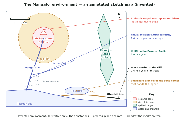
Two environments run through this topic, and one of them is not real
- Taranaki Maunga is real, and every figure given for it on this page is published. It is used here because choosing an environment is a decision about a real place, and you need to see the test applied to one.
- Everywhere else on this topic the environment is Mangatoi — Mt Rakaunui, the Puketiro Range, the Mangatoi River, Ōtaraki Head and Te Waiora lagoon. None of them exist. Every name, altitude, rainfall total, rate, date and thickness in Mangatoi was invented for these pages, and each page says so.
- Why invent one at all. The later pages need a rate for every process in one system so you can watch six of them interlock. No single published New Zealand environment has all six figures available, and inventing rates for a real mountain would be far worse than inventing a mountain — you could end up quoting them as fact.
- So: never quote a Mangatoi figure in an exam. Learn the method on it, then run your own class's environment — with its real names and real figures — through the same steps.
Choosing the processes you will name
- Name processes, not features. The river is a feature. Fluvial erosion, transport and deposition is a process. The naming box wants the second kind.
- Pick processes from at least two different families, because interaction between two river processes is thinner than interaction between a volcanic process and a river process.
- The families you can draw on are volcanic and tectonic (eruption, lahar, uplift, faulting), climatic (rainfall, wind, temperature, freeze-thaw), mass movement (slips, debris flows, slumping), fluvial (erosion, transport, deposition), coastal (wave erosion, longshore drift, dune building) and glacial where the environment has ice.
- For Taranaki the named set would be: andesitic eruption (last about 1790), lahars and debris avalanches running 30–40 km to the coast, orographic rainfall falling from 8,000 mm a year on the mountain to 1,400 mm at New Plymouth, radial fluvial erosion across the ring plain, and wave erosion retreating the sea cliffs at 0.14 m a year. Every one of those is a process with a figure attached.
- Three or four processes is enough. More than that and you cannot explain any of them in detail inside the time.
Evidence, and what makes it count at Level 3
- Evidence means specifics from your environment: named features, figures, rates, dates, thicknesses and distances. Nothing else you do changes the quality of an answer as much.
- Supporting evidence is a specific fact attached to a correct explanation.
- Detailed evidence is quantified and located: not the cliff is eroding but the Taranaki sea cliffs retreated at an average of 0.14 m a year between 1883 and 1979, and up to 0.44 m a year at the fastest point.
- Integrated evidence is examples woven throughout the explanation. The figure sits inside the sentence making the point, and the same figure is used again later to support a different link.
- Build an evidence sheet while you revise — one line per fact, about twenty figures. Twenty is enough for any question this paper asks, and rates are the most useful kind.
Level 2 to Level 3: what actually changed
- At Level 2 you explained aspects of an environment. Here you analyse how the processes interact — the same material, plus what the parts do to each other.
- Description of four characteristics will not pass here. The verb in the title is about processes shaping an environment, so the answer is built around mechanisms, not around lists.
- The drawing is new. Nothing at Level 2 required a constructed annotated diagram; here it is part of the question.
- The word "interacting" is the whole standard. If your answer would still make sense with the processes described one after another in separate paragraphs, you have not answered it.
Worked Example
A student has to fill in the naming box at the top of the paper, which asks for the New Zealand environment and the interacting natural processes that shape it. Here are three attempts. Diagnose each, then write the version that sets the answer up properly.
- Attempt 1: Environment: Dawson Falls. Processes: erosion.
- Attempt 2: Environment: the Waingongoro River. Processes: the river, the mountain, the sea.
- Attempt 3: Environment: Taranaki, North Island, NZ. Processes: erosion and deposition.
Step 1 — test each environment against the size condition.
A geographic environment has to be an area large enough for several interacting natural processes. Dawson Falls is one landform and fails immediately. The Waingongoro River is better but still a single feature — a line on a map, not an area. Attempt 3 names an area and locates it in New Zealand, so only attempt 3 passes.
Step 2 — test each list against "processes".
Attempt 2 lists features (the river, the mountain, the sea), not processes. Attempt 1 and attempt 3 name real processes but keep them generic: erosion on its own does not say what is eroding what, or how fast.
Step 3 — check that the processes come from more than one family.
Attempt 3's erosion and deposition are both fluvial. Two processes from one family can only interact in a limited way, which caps the answer before it starts.
Step 4 — write the version that sets the answer up.
Environment: Taranaki Maunga and its ring plain, over 2,000 km2 of the western North Island, from the summit at 2,518 m across the ring plain to the Tasman coast between Cape Egmont and Hāwera.
Interacting natural processes: andesitic volcanic activity (tephra fall, lahars and debris avalanches, last eruption about 1790); mass movement, with at least five collapses of the cone in 50,000 years sending avalanches 30–40 km to the sea; orographic rainfall, from 8,000 mm a year high on the mountain to 1,400 mm at New Plymouth; radial fluvial erosion, transport and deposition across the ring plain; and coastal wave erosion, retreating the sea cliffs at 0.14 m a year.