Mapping skills
The conventions, which are marked directly
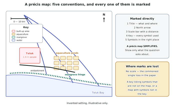
- Five conventions, and they are worth marks whether or not the question mentions them: title, north arrow, scale, key, correct symbols in the correct places.
- The title says what and where. Land use in the Sarupa delta, 2025 — not Map.
- A scale bar is safer than a stated ratio, because a scale bar survives photocopying and lets you measure directly.
- The key lists every symbol you used and nothing you did not. A key with an unused symbol, or a map with an unkeyed symbol, both lose the same mark.
- Missing the scale is the commonest single loss in the paper, and it takes ten seconds to avoid.
Précis maps: the skill is leaving things out
- A précis map simplifies a complex map to show one thing clearly. The skill being marked is selection, which is this standard's central idea.
- Decide what the map is for before you draw a line. A précis map of land use should not carry contours; one of relief should not carry shop locations.
- Draw boundaries as smooth generalised lines, not as traced detail. Precision at Level 3 means accurately placed, not finely drawn.
- Shade areas, do not outline everything. Coloured pencil for areas, pen for annotations — both are named in the assessment specification.
- Label the features the question names, and locate them where they actually are relative to each other. A map with correct symbols in the wrong places is worse than one with fewer symbols.
Grid references, distance and direction
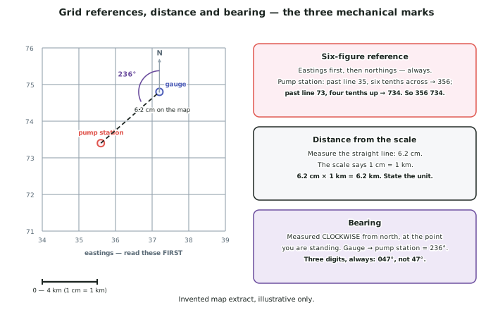
- Eastings first, then northings. Always. Along the corridor and up the stairs is the standard mnemonic and it is worth repeating in your head under pressure.
- A four-figure reference names a square; a six-figure reference names a point inside it to the nearest tenth. Read the line to the left of the point, then the line below it.
- Distance: measure in centimetres, then convert with the scale, then state the unit. A straight-line distance of 6.2 cm on a map where 1 cm = 1 km is 6.2 km.
- For a distance along a road or river, use the edge of a piece of paper and mark each bend, or a piece of string. A straight-line measurement of a curved feature is a wrong answer, not an approximation.
- Direction: use eight compass points unless a bearing is asked for. A bearing is measured clockwise from north, at the point you are standing, and is written with three digits — 047°, not 47°.
Cross-sections and area
- A cross-section shows relief along a line, and it is the fastest way to answer any question about what the land does between two points.
- Method: mark the contour crossings along the edge of a strip of paper, transfer them to a grid with height on the vertical axis, plot each point, join with a smooth curve, and state the vertical exaggeration.
- Area from a grid: count the whole squares, then count part-squares as half. State the answer in the unit the grid gives you — about 12 km2.
- Do not calculate to more precision than the method allows. About 600 km2 is honest for a scale-bar measurement; 612.4 km2 is not.
- On any drawn answer, annotate rather than label, exactly as in AS91426 and AS91427 — a sentence explaining a feature is worth more than its name.
Choosing a mapping skill in an exam with no instructions
- The question will not say "use the scale". You decide that the answer needs a distance and go and get one.
- Three prompts that should trigger a mapping skill:
- a question about location → grid reference, direction, relative position
- a question about extent or size → scale bar, area estimate
- a question about a spatial pattern → describe the arrangement, then quantify it with two located figures
- State that you measured. Measured from the scale bar on resource A, the delta is about 31 km from apex to coast shows the skill; the delta is 31 km long hides it.
- Precision is a Merit word in this standard. Accurate placement, correct conventions and stated units are precisely what it means.
Worked Example
Worked example
Using resource A, describe the location of the aquaculture ponds relative to the city of Teluk, and calculate the straight-line distance between them.
Answer:
Step 1 — decide which skills the question needs. Nobody has told you. Location relative to needs direction and relative position; straight-line distance needs the scale bar. Two skills, selected.
Step 2 — give the relative position first, in words.
The aquaculture ponds occupy the central third of the delta, immediately east of the city of Teluk and inland of the mangrove fringe. They lie between the second and third distributary channels, and the embankment runs between them and the city.
Step 3 — add a grid reference so the position is absolute as well as relative.
The western edge of the pond block sits at about 365 731; the eastern edge of the built-up area of Teluk sits at about 352 733.
Step 4 — measure, then convert, then state the unit.
The straight-line distance between the two on the map is 3.9 cm. The scale bar shows 1 cm = 1 km.
3.9 cm × 1 km/cm = 3.9 km
Step 5 — give the direction as a bearing, because it is more precise than a compass point.
Measured clockwise from north at the edge of the city, the ponds lie on a bearing of about 084° — very close to due east.
Step 6 — say what the measurement is worth.
The ponds are close enough to the city that the embankment protects both, which matters for any later question about flooding: a defence failure would not be an agricultural problem or an urban one, it would be both.