The paper, the booklet, and selection
What is different about this standard
- There is no case study. The environment arrives with the paper, in a separate resource booklet (91429R) pulled from the centre of the exam.
- The concept definitions are printed on page 2 of that booklet. You are not marked on recalling them; you are marked on using them.
- The setting has been overseas in every year checked, and the 2026 specification requires it. Recent papers have used places as different as a mining region, a flood-prone delta and a capital city relocation.
- Nothing about the environment can be prepared in advance, and that is the design of the standard. What you prepare is method.
- The worked environment on these pages is invented: the Sarupa delta in Kalindra province, with the city of Teluk (1.9 million people), aquaculture ponds, a mangrove fringe and an embankment, subsiding by up to 2.3 m since 1990.
The shape of the paper
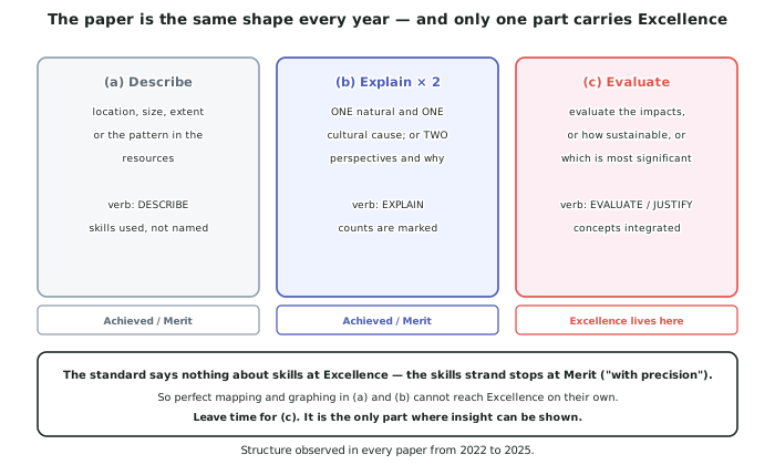
- ONE question, ALL parts compulsory. As in every Geography external, there is no choice.
- Part (a) is a description task — the location, size and extent of a place, or the spatial or temporal pattern shown in the resources.
- Part (b) is a two-item explanation task — one natural and one cultural cause, or two different perspectives and why people hold them. The count is stated and it is marked.
- Part (c) is an extended evaluation — evaluate the impacts, how sustainable is this likely to be, what is the most significant impact — justify your response.
- There are no short mechanical skills questions. Unlike AS91243, the skills are used inside your prose answers, so nobody tells you when to calculate or when to describe a pattern.
Selection: the whole difference from Level 2
- At Level 2, AS91243 tells you the skill. Complete the précis map. Give the six-figure grid reference. Calculate the distance.
- At Level 3 nobody tells you. The question asks about the environment, and you decide that a distance calculation, a median rather than a mean, or a photograph's camera direction is what supports your point.
- So the skill you are being marked on is fitting the tool to the job, and it is worth practising as its own thing.
- Three decisions you will make in every paper:
- which resource answers this part — often two of the six do, and one does it better
- which measure describes the data honestly — mean, median, mode, range, percentage, rate
- which concept the evidence actually demonstrates, rather than which one you like best
- Say you selected. The median is the fairer measure here because one site is extreme earns more than a correct median with no reason given.
Using the resource booklet properly
- Spend the first three minutes reading all the resources before you write anything. Every year candidates answer part (a) from resource A and never notice that resource E contains the figures that would have made it a Merit answer.
- Number your evidence as you read. A quick list — B: population 1990–2025; C: subsidence map; D: two quotations — turns six resources into a menu.
- Quote from the resources. The instruction to integrate supporting evidence from the resources appears in the paper every year, and unsupported general knowledge is worth very little here.
- Do not import your own case study. You may use your wider geographic knowledge to explain, but the evidence must come from the environment supplied.
- Watch for a resource that disagrees with another. Papers include them deliberately, and noticing the disagreement is usually worth a mark in part (c).
Equipment and conventions
- Bring a ruler, a calculator and coloured pencils. All three are named in the assessment specification, and annotations must be in pen.
- The mapping conventions are marked directly: title, north arrow, scale, key, correct symbols.
- Round sensibly and state units. 6.2 km, not 6.2. A number without a unit is not an answer in this standard.
- Show your working for any calculation, even a one-line one — a wrong final figure with correct method still earns something.
Worked Example
Worked example
A resource booklet on the invented Sarupa delta contains six resources: (A) a location map, (B) a table of Teluk's population 1990–2025, (C) a subsidence map, (D) two quotations from residents, (E) a climate graph, and (F) a photograph of the embankment.
Part (a) asks: Describe the location and extent of the Sarupa delta.
Which resources would you select, and why? Then write the answer.
Answer:
Step 1 — decide what the verb needs. Describe location and extent needs where it is (absolute and relative), how big it is, and what it consists of. It does not need causes.
Step 2 — select. Resource A (the location map) carries all three, provided a scale bar is present. Resource C adds extent, because a subsidence map covers the same area and gives a second measure of it. Resources B, D, E and F answer later parts — do not use them here just because they are there.
Step 3 — decide which skills you need. Two, and neither is announced by the question: reading direction and distance from a map, and using the scale to quantify extent.
Step 4 — write it.
The Sarupa delta lies on the northern coast of Kalindra province, where the Sarupa River enters Teluk Bay (resource A). Its absolute location on the booklet map is between the 34 and 38 eastings and the 71 and 75 northings; its relative location is about 14 km north of the hill country visible in resource F, and immediately south-west of the bay.
Measured from resource A with the scale bar, the delta is about 31 km from its landward apex to the coast and about 26 km along the shoreline, giving an area in the order of 600 km2. Within that extent it contains three main distributary channels, the built-up area of Teluk on the western side, a block of aquaculture ponds covering roughly the central third, and a mangrove fringe along most of the seaward edge.
Resource C shows the same extent again from a different angle: the area affected by subsidence of 1 m or more covers most of the delta but stops at the landward apex, which confirms that the delta and the subsiding ground are effectively the same area.