Interpreting visual material
What "visual material" means in this paper
- Visual material is anything in the booklet that is not a map, a graph or a table: photographs, oblique and aerial views, satellite images, diagrams, cartoons and field sketches.
- Every one of them is evidence, and the instruction to integrate evidence from the resources includes them.
- A photograph is data, not decoration. Papers have asked directly for the direction the camera was facing, and for changes visible between two images of the same place.
- The skill is separating three things: what you can see, what you can infer, and what you cannot know from the image.
- Say which you are doing. The image shows…, which suggests…, though the image cannot tell us… — three phrases that keep the answer honest and demonstrate the skill.
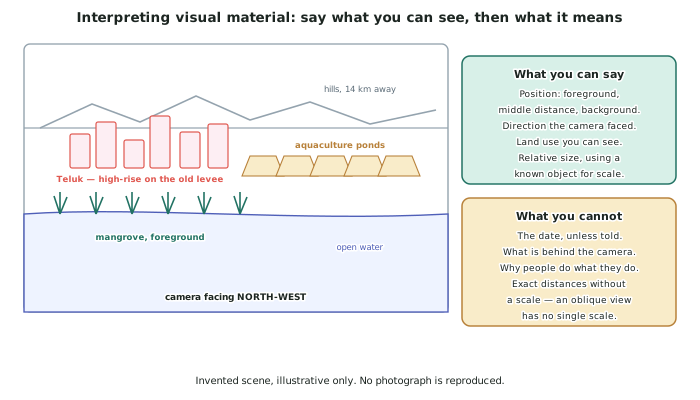
A method for any photograph
- Divide it into foreground, middle distance and background and describe each in turn. This alone gives structure to an answer that would otherwise wander.
- State the camera direction if it can be worked out — from the map, from shadows, or from a feature you can locate. Papers ask for it.
- Find something of known size for scale: a person, a vehicle, a building storey (about 3 m), a shipping container.
- Look for evidence of process, not just of things. Bare soil at the top of a slope, sediment plumes in water, dead vegetation at a shoreline, sandbags, repaired walls — all of them record something happening.
- Look for evidence of decisions. An embankment, a fence line, a drain, a cleared strip and a new road are all somebody's choice, and they connect the physical evidence to the cultural process.
Reading the invented Sarupa delta view
- Foreground: mangrove and open water, with the mangrove standing in water rather than on exposed mud — evidence that the tide reaches further than it once did.
- Middle distance: aquaculture ponds, in a regular rectangular block, which is the shape of ownership rather than of any natural process.
- Behind them: the embankment, and behind that the high-rise of Teluk built on the old levee.
- Background: hills about 14 km away, which give the viewer a direction and a rough scale.
- The camera faces north-west, which can be checked against the map: the hills are inland and the bay is to the right of frame.
What an image cannot tell you
- The date, unless the booklet supplies it. Never assume a photograph is current.
- What is behind the camera, which is often exactly the part of the environment the question is about.
- Why people did anything. An image can show an embankment; it cannot show who paid for it or what they were worried about.
- Exact distances in an oblique view, because an oblique view has no single scale — near objects are drawn at a different scale from far ones.
- Anything about a place other than the one shown. One district is not the city.
Comparing two images, and using images with other resources
- When the booklet supplies two images of one place, the question is almost always about change. Work through the same three zones in both and list what is different.
- Be specific about what changed: an area of mangrove replaced by ponds, a shoreline that has moved, a building abandoned, a wall raised.
- Then quantify the change from another resource. The image shows that the ponds expanded; the table says by how much. An image plus a figure is far stronger than either alone.
- Use images to check the other resources. If a table claims growth and a photograph shows abandoned buildings, that disagreement is worth a paragraph — see the page on selection.
- Never treat an image as proof of a general claim. It is evidence about one place at one moment, and saying so is a mark of precision rather than a weakness.
Worked Example
Worked example
Using the photograph in resource F, describe what it shows about the environment, and explain what can be concluded from it.
Answer:
Step 1 — state the viewpoint and direction, which is a mark on its own.
The view is oblique, taken from above the mangrove fringe looking north-west across the delta towards the hills about 14 km away. This can be checked against resource A: the hills lie inland and the bay is off to the right of frame.
Step 2 — describe the three zones in order.
- Foreground: mangrove standing in open water, with no exposed mud between the trees and the water's edge.
- Middle distance: a regular block of rectangular aquaculture ponds, and beyond them a continuous raised embankment.
- Background: the high-rise of Teluk on the far side of the embankment, and the hills on the skyline.
Step 3 — separate what can be seen from what can be inferred.
Seen: mangrove in standing water; ponds in a rectangular grid; an embankment between ponds and city; tall buildings behind it.
Inferred: mangrove standing in water rather than on exposed mud suggests the tidal range now reaches further inland than the trees established in; the rectangular pond block suggests ownership and planning rather than a natural feature; the embankment's position — between the ponds and the city rather than along the coast — suggests it was built to keep water out of the city specifically.
Step 4 — say what cannot be concluded.
The image cannot date any of this, cannot show whether the mangrove is advancing or retreating, and cannot show conditions on the far side of the city. It shows one place at one moment.
Step 5 — combine it with another resource, which is what lifts the answer.
Read with the subsidence map, the embankment's position becomes informative rather than merely visible. The map shows 2.3 m of subsidence in the districts immediately behind that embankment. So a wall built to a fixed height is now standing on ground more than two metres lower than when it was designed — and the abandoned buildings visible behind it are what that looks like from the outside.