What geographic research is
What this standard actually assesses
- AS91244 assesses a process, not a topic. Two students can hand in reports on completely different places and both reach Excellence, because the marker is checking the seven steps, not the subject.
- That is unusual, and it changes how you should work. In an external you are rewarded for knowing more. Here you are rewarded for doing each step properly and saying why you did it that way.
- The seven steps are named in the standard itself, so nothing is hidden. Write them down the side of your planning sheet and tick them off.
- The largest single cause of lost grades is a missing step, not a weak one. A report with brilliant data and no evaluation cannot be Achieved.
The seven stages, and how they fit together
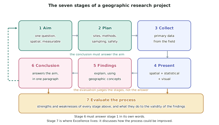
- Stages 1 and 2 — aim and plan — happen before you leave the classroom, and this is where guidance is allowed.
- Stage 3 — collect and record — is the field day. Recording is a separate word from collecting on purpose: data you measured but did not write down properly is gone.
- Stage 4 — present — turns raw numbers into maps, graphs and images that follow conventions.
- Stage 5 — findings — is where you explain what the data shows and bring in geographic concepts.
- Stage 6 — conclusion — answers the aim, in the aim's own words.
- Stage 7 — evaluation — judges the process: what was strong, what was weak, and what that does to how much your findings can be trusted.
- Notice what the arrows do. The conclusion answers the aim, so stage 6 must point back at stage 1. The evaluation sits under the whole sequence, because it judges the stages, not the answer.
What "with guidance" means, and what it does not
- With guidance is defined in the standard: the student is supported to identify the aim and supported to choose the methods of collecting, recording and presenting data.
- So you may ask whether your aim is workable, which sampling design suits your sites, and what kind of graph fits your data. Ask all of it, early.
- You may not be guided through the explanation, the conclusion or the evaluation. Those are the parts being judged.
- Group collection is explicitly allowed. You can measure with three classmates and share the raw numbers. Everything after collection must be your own — your presentation, your explanation, your conclusion, your evaluation.
- Level 3's version of this standard, AS91430, says with consultation instead, which means less help. If you are told the L3 rules, they are not these.
The spatial component — the test your topic must pass
- Geographic research must have a spatial component. The data has to differ from place to place, and you must be able to show that on a map.
- A one-site study fails this test. Measuring the Waipuna Stream at Rimu Bridge fifty times gives fifty numbers about one place and no geography.
- The fix is always the same: add places. Six sites down the stream, ten sites across a suburb, four sites around a lake. Then distance, direction and location become variables you can explain with.
- Temporal change counts as well as spatial, and the strongest projects have both — the same sites measured at two times, or measured now and compared with a referenced historic record.
- Three questions to run any proposed aim through:
- Can I put a number or a category on it? If not, I cannot present it statistically.
- Can I collect it myself in one field day? If not, it is not primary research.
- Would the answer be different at different sites? If not, it has no spatial component.
Choosing a project that survives the field day
- Prefer a variable that changes obviously over a short distance. Stream width down a catchment, land use along a main road, shade cover across a park, noise across a suburb, wave height along a bay.
- Check access and safety before you commit. A site you cannot legally or safely reach is not a site, and a plan that ignores this gets rewritten on the day, which weakens your data.
- Prefer a topic with an existing secondary source, such as council records or a published dataset, because being able to compare your field results with someone else's is the cheapest route to a strong evaluation.
- The worked project in this topic is the invented Waipuna Stream study at the invented town of Kotarehu: six sites, 2 km apart, from the foothills to the coast, measuring channel width, depth, velocity and bedload, with a précis sketch and photograph at each site and a short questionnaire in the town about flooding. Every figure in it was written for these pages.
Worked Example
Worked example
Four students propose these projects. Decide which are valid AS91244 research projects, and fix the ones that are not.
- A: An investigation into climate change.
- B: Measuring the depth of the Waipuna Stream at Rimu Bridge every hour for a day.
- C: How and why does the channel of the Waipuna Stream change between the Kotarehu foothills and the coast?
- D: Do people in Kotarehu like the river?
Answer:
Step 1 — apply the three tests: measurable, collectable in the field, spatially varying.
A fails all three. Nothing about it can be measured by a Year 12 student in a day, none of the data would be primary, and there is no site. Reject — it is a reading topic, not a research topic.
B passes measurable and collectable but fails the spatial test. It is one place, so distance cannot be a variable and no meaningful map can be drawn. Fix it: keep the method and add places — depth at six sites 2 km apart down the stream. That is exactly project C.
C passes all three tests as written. One stream, six sites, four measurable variables, and the word why built into the aim so the explanation stage is already signalled. Accept.
D is a real geographic question buried in an unusable one. Like cannot be measured and there are no sites. Fix it: What proportion of residents in each of four Kotarehu streets at different distances from the stream report worrying about flooding? That is a questionnaire with a spatial component, and it pairs with C rather than replacing it.
Step 2 — check each fixed project can be explained, not only described.
Fixed B, now C, can be explained by discharge increasing downstream as tributaries join. Fixed D can be explained by distance from the channel and by height above it. A project you can measure but not explain stalls inside Achieved, so run this check before you buy a tape measure.