What counts as a contemporary NZ geographic issue
Four tests your topic has to pass
- Test 1 — is it in New Zealand? The standard says a local or national issue within New Zealand. Climate negotiations in Europe, deforestation in the Amazon and a dam in Asia all fail here, whatever else they have going for them.
- Test 2 — is it contemporary? It must be affecting people or places now or in the near future. A finished argument that everybody has moved on from is history, not an issue.
- Test 3 — is it an issue? There must be a debate. If everybody agrees, there are no viewpoints to explain and no courses of action to weigh, and three of the five required parts have nothing to work with.
- Test 4 — is it geographic? It must relate to a natural or cultural environment and it must have a spatial dimension. This is the test topics usually fail.
What "spatial dimension" actually means
- The issue has to be different in different places, and you have to be able to show the difference on a map.
- The quick check: if you drew a map of your issue and every part of it looked the same, there is no spatial dimension.
- Two topics that sound similar but split on this test. Whether New Zealand should lower the voting age is a real, current, contested issue — but it is the same everywhere, so it is not geographic. Where a new landfill should go is the same argument attached to particular places, and it is.
- A spatial dimension is not the same as "it happens outdoors". It means the pattern of the problem varies over space — worse downstream than upstream, worse on one coast than another, worse in one suburb than the next.
The worked issue: nitrate in the invented Ōhaupara catchment
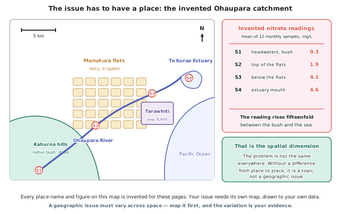
- The issue: nitrate and sediment entering the Ōhaupara River, and what should be done about it.
- It is in New Zealand and it is local — a single catchment of about 640 km2.
- It is contemporary: the regional council has a draft plan change out for consultation, so the decision is in front of people now.
- It is contested: the 118 dairy farms in the catchment, the residents of Tarawhiti, the local hapū, the regional council and a community group all want different things.
- It has a spatial dimension, and the map proves it. Nitrate reads 0.3 mg/L where the river leaves the bush and 4.6 mg/L at the estuary — roughly fifteen times higher at the bottom than at the top. The problem is not spread evenly; it is made in one part of the catchment and felt in another.
Where the marks come from
- Five parts, and each is separately assessed. Describe the nature; explain the viewpoints; describe how one viewpoint changed; explain the strengths and weaknesses of the courses of action; recommend one with a reason.
- The five parts are not equal in difficulty. Parts 1 and 3 are described; parts 2 and 4 are explained; part 5 is where Excellence is decided.
- Choose the issue with the five parts in mind. An issue with only two groups involved makes part 2 thin. An issue nobody has changed their mind about makes part 3 impossible.
- Check part 3 before you commit. Has any group's position on this moved in the last fifteen years, and can I show what moved it? If the honest answer is no, choose a different issue now rather than three weeks in.
Evidence, and what counts
- Primary data is strongest — your own water tests, counts, photographs, surveys or interviews. It is also the easiest to describe in detail, because you know exactly where and when it came from.
- Secondary data is allowed and often necessary — council monitoring reports, regional plans, Stats NZ figures, news coverage — but it must be specific and referenced, not remembered.
- Keep an evidence sheet from day one: one line per fact, with its source and its date. Twenty solid lines carry this standard.
- Never reproduce somebody's submission or a consultation document. Summarise a group's position in your own words and say where you found it.
Worked Example
Worked example
Four students propose topics for AS91245. Decide which are valid, and fix the ones that are not.
- A: Should New Zealand raise the minimum wage?
- B: Coastal erosion at the invented settlement of Rukuwai, and whether the council should build a seawall or move the road.
- C: Deforestation in the Amazon.
- D: Pollution.
Answer:
Step 1 — run the four tests on each.
A is in New Zealand, contemporary and contested, but it fails the geographic test. The minimum wage is the same figure in Kaitāia and Bluff, so there is nothing to map and no spatial variation to describe. Reject. It could be rescued only by changing the question to something like where in New Zealand a wage rise would have the largest effect on employment, which is a different topic and a much harder one.
B passes all four. It is in New Zealand; the council decision is live; the residents, the council and road users disagree; and the erosion rate differs along the shore, so it maps. Accept.
C fails test 1 outright. It is a real geographic issue, but it is not in New Zealand. Reject — and note that no amount of extra work fixes this one.
D fails tests 2, 3 and 4 at once. Pollution names no place, no time and no argument. Fix it by adding all three: sediment entering Te Kūrae Estuary from the Manukura flats, and whether the regional council should require fencing. That is now one substance, one place, one decision and one set of groups.
Step 2 — check the survivors against part 3.
For B, has a viewpoint moved? Yes: the residents' association argued for a seawall for years and shifted to supporting road relocation after the invented 2023 storm damaged the first seawall section. The change has a date and a trigger, so part 3 is safe.
For fixed D, the farmers' position has moved from denial to accepting fencing. Also safe.