Planning and decision making
What this section has to contain
- The standard asks you to explain the planning and decision making behind the event — not just that it was planned, but who decided what, on what grounds, and when.
- Find the decisions, not the timeline. A schedule of what happened when is a narrative. A decision has options, a decider, criteria and a date.
- Every event has at least five decisions worth analysing: whether to hold it, where to hold it, when to hold it, how to fund it, and how to move people around it.
- The "where" decisions are the geographic ones, and they are where this standard's marks concentrate.
- Name the decision-makers. A council, a trust, a national body, a sponsor, a landowner, mana whenua, a regulator. It was decided is not an explanation.
Finding the evidence
- Council agendas and minutes are public and are the single best source: they record what was proposed, what the options were, who voted and what reasons were given.
- Resource consent applications and decisions record the environmental conditions imposed and the objections received.
- Transport and event management plans record the movement decisions and the modelling behind them.
- Interviews with an organiser, a council officer or an affected resident give reasons that documents leave out.
- Media coverage is useful for the disagreements, but check it against the primary documents before quoting a figure.
Explaining a decision properly
- Four moves: the decision, the options, the criteria, the outcome.
- Worked on the invented Manawa Games: the decision was where to put the athlete village; the options were a greenfield site 9 km south, the existing polytechnic halls near the stadium, and a temporary village on the stadium car park; the criteria were cost, travel time for competitors, and legacy use afterwards; the outcome was the polytechnic halls, because they cost $2.4 m against $7.1 m for the greenfield option and left a permanent asset in student accommodation.
- Say what was traded away. Choosing the halls meant no new housing legacy for the city, which was one of the bid's stated benefits.
- A decision explained without its rejected options is not explained. The alternatives are what make the criteria visible.
The geography inside the decisions
- Where decisions are made about are the ones this standard cares about. Venue selection, transport routing, road closures, park-and-ride siting, waste and water servicing, and any construction.
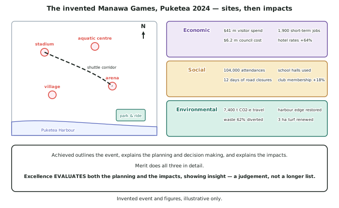
- Ask what the physical environment forced. In the invented example, the arena is on the harbour edge, so extra spectator capacity required rebuilding 600 m of shoreline — the environment set the cost of the decision.
- Ask what the existing pattern forced. Puketea's venues are 7 km apart because they were built for different local catchments decades earlier, and that inherited pattern forced the shuttle corridor.
- Ask who was not in the room. Residents on the shuttle corridor, businesses inside the closure area, and users of the facilities during the build are affected by decisions they had no part in.
- This is the interaction between people and the environment, expressed through decisions — which is exactly what a geographic perspective means.
Perspectives on the planning
- Different groups judged the same decisions differently, and saying so is a straightforward route into the analysis.
- The organisers valued delivery: on time, on budget, venues full.
- The council balanced statutory duties, a rates cap and a legacy claim it had made publicly.
- Residents on the shuttle corridor valued being able to get to work, and had no say in the routing.
- Mana whenua in the invented example were involved in the harbour-edge design, which changed the planting and the alignment.
- Give each group a reason grounded in what they depend on, not a personality.
Worked Example
Worked example
Explain the planning and decision making behind one aspect of a significant contemporary event you have studied.
The aspect chosen: how spectators would move between venues at the invented Manawa Games.
Answer:
Step 1 — state the decision and why it existed.
The venues are dispersed across about 7 km, so spectators attending more than one session had to cross the city. Doing nothing was not viable: the city's normal bus network runs on a 30-minute frequency and would have been overwhelmed by a peak demand of about 9,000 trips a day.
Step 2 — set out the options that were considered.
- Use the existing bus network, with extra services.
- A dedicated shuttle corridor across the CBD, with 12 streets closed to general traffic.
- Park-and-ride only, with spectators driving to a single southern site and shuttling from there.
- No special provision, leaving people to drive and park locally.
Step 3 — name the decision-makers and the criteria.
The decision sat with the city council (which controls the roads) rather than with the trust, and the criteria recorded in its minutes were journey time between venues, cost, disruption to residents and businesses, and safety of pedestrian crowds.
Step 4 — explain the outcome and what it traded away.
The council chose option 2 with a park-and-ride attached — the shuttle corridor plus the southern site. It gave the shortest journey time (about 14 minutes venue to venue) and kept crowds off general traffic lanes. What it traded away was ordinary access to the CBD for 12 days, which fell on businesses and residents who were not attending the Games. Option 4 would have had zero cost and produced the residential parking overflow the council was trying to avoid.
Step 5 — bring in the geography that forced the decision.
None of this would have arisen if the venues were clustered. The corridor exists because the city's sports facilities were built decades earlier for different local catchments, and an event held in 2024 inherited that pattern and had to route around it.