The factors and processes behind the pattern
What the standard means by causes
- The standard splits causes into two kinds: factors — circumstances that contribute to the pattern — and processes — a sequence of events.
- A factor is a condition. Aridity, population density, income, geology, distance from a river, political stability.
- A process is a sequence. Urbanisation, agricultural intensification, aquifer depletion, climatic change, industrialisation.
- Use both, and label which is which. Aridity is a factor; aquifer depletion is a process takes six words and shows you have read the standard.
- A cause with no mechanism is a label. Population growth causes water scarcity is a label; each additional person adds domestic demand, and rising incomes add far more through diet and industry, so demand grows faster than population is a cause.
Causes at two scales, which is what makes it geographic
- Global-scale causes explain why the pattern exists at all: the subtropical high-pressure belts that produce the arid belts around 30° north and south; the global distribution of population; global trade in water-intensive goods.
- Country-scale causes explain why places inside the same band differ: income, infrastructure, governance, storage capacity, and whether a country can substitute technology for rainfall.
- A report with only global causes cannot explain the anomalies; a report with only national causes cannot explain the bands.
- Say explicitly which scale each cause operates at. That single habit turns a list of causes into an analysis.
- The best evidence for a cause is a place where it is absent. A dry, wealthy country with low recorded stress shows that aridity alone does not determine the outcome.
The worked topic: what causes water scarcity
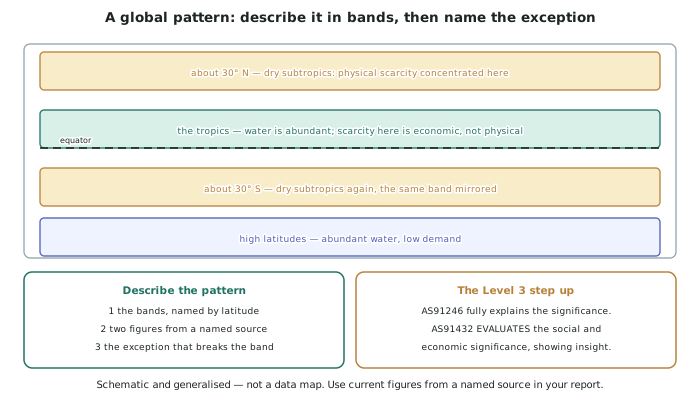
- Factor — aridity (global scale). Descending air in the subtropical high-pressure belts produces low rainfall and high evaporation around 30° north and south. This is why the physical component of the pattern is latitudinal and mirrored in both hemispheres.
- Factor — population distribution (global scale). Some of the world's densest populations sit in river basins with large but finite flows, so a large supply is divided among very many users.
- Process — rising per-capita demand (all scales). Demand grows faster than population because diets, industry and energy production use far more water per person as incomes rise.
- Process — aquifer depletion (regional scale). Where extraction exceeds recharge, groundwater levels fall, which converts a stored supply into a declining one and makes today's use a subtraction from tomorrow's.
- Factor — infrastructure and finance (country scale). This is the cause of economic scarcity: water is present, and the storage, treatment and distribution to deliver it reliably is not.
Linking causes to the pattern you described
- Every cause should explain a specific feature of your pattern, not the topic in general.
- Aridity explains the belts. Population density explains the South Asian concentration. Infrastructure explains the humid-tropic anomaly. Rising demand explains the temporal trend.
- If a cause explains nothing specific in your description, cut it. Reports fill up with true statements that account for no feature of the map.
- Where two causes are needed together, say so. The South Asian concentration requires both a large population and a finite basin; neither alone produces it.
- Say which cause dominates where, because that is the analysis rather than the list.
Interconnection, which is where the marks concentrate
- Global topics are interconnected, and showing the connections is what lifts a causes section.
- Water scarcity connects to food, because most freshwater use is agricultural, so a food decision is a water decision.
- It connects to trade, because importing water-intensive goods is effectively importing water — which is how some arid countries manage.
- It connects to energy, because thermal power generation and some renewables use water, and desalination uses energy.
- These connections explain the anomalies better than any single cause does: a wealthy arid country with low stress is usually importing both water-intensive food and the energy to desalinate.
Worked Example
Worked example
Explain the factors and processes that cause the global pattern of water scarcity.
Answer:
Step 1 — take each feature of the pattern in turn, rather than listing causes.
Feature 1 — the arid belts around 30° north and south.
Cause: aridity (factor, global scale). Air rising at the equator loses its moisture, travels poleward at height, and descends around 30° in both hemispheres. Descending air warms, its capacity to hold vapour rises, and it does not rain. This is why the physical component of the pattern is latitudinal and mirrored — a pattern of that symmetry cannot be caused by anything national.
Feature 2 — the concentration in densely populated river basins.
Causes: population distribution (factor, global) plus rising per-capita demand (process, all scales). A large river can supply a large population, but not an unlimited one, and demand per person rises with income far faster than population does — through diet, industry and energy. Neither cause produces this concentration alone: the basin has water, and the population by itself would be manageable at lower per-capita use.
Feature 3 — the humid-tropic anomaly: wet countries with high scarcity.
Cause: infrastructure and finance (factor, national scale). Rainfall is abundant; storage, treatment and distribution are not. This is economic scarcity, and it is invisible in any climatic explanation — which is why the anomaly exists at all.
Feature 4 — the rising trend over recent decades.
Causes: population growth and rising demand (processes), plus aquifer depletion (process, regional). Where extraction exceeds recharge, a stored supply becomes a declining one, so present use subtracts from future availability. This is the cause that changes the character of the problem rather than its size.
Step 2 — use the interconnections to explain the hardest case.
Dry, wealthy countries with low recorded stress appear to contradict the aridity explanation. They do not, once trade and energy are included: such countries typically import water-intensive food — effectively importing water — and use energy to desalinate. So the aridity is unchanged and the scarcity has been exported to the countries growing the food and the atmosphere absorbing the emissions.
Step 3 — state which cause dominates where, which is the analysis.
Aridity dominates the belts; population and demand dominate the basins; infrastructure dominates the tropics; and wealth determines whether any of them results in recorded scarcity at all. That last point is the one a purely physical account cannot reach.