The aim and the methodology
What makes an aim work
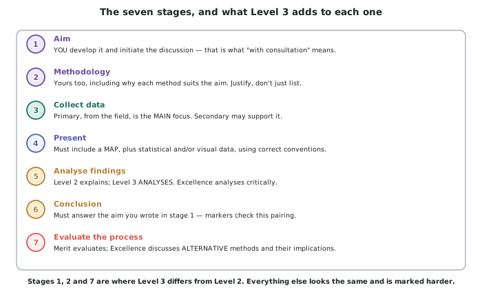
- An aim states what you will find out, where, and over what period. All three, in one sentence.
- It must have a spatial component. This is geography: the aim has to be about where, not only about how much.
- It must be answerable with data you can actually collect in the time and the places you have access to.
- A good aim in the invented worked study: To investigate how water quality in the Rerenga catchment varies with distance downstream and with the land use adjacent to each site, over four sampling days in March.
- A weak version of the same idea: To investigate water quality in the Rerenga. No spatial variable, no period, and no way to know when it has been answered.
Turning an aim into questions and a hypothesis
- Break the aim into two or three focusing questions, each of which one set of measurements can answer.
- In the invented study: (1) How does nitrate concentration change downstream? (2) Does it change more where land use changes? (3) Is the pattern the same on all four sampling days?
- A hypothesis is optional but useful, because it makes your method's job obvious: nitrate will rise downstream, and will rise fastest below the pasture reach.
- Say what result would disprove it. Research that cannot come out the other way is not research.
- Keep the scope small. Five sites measured carefully on four days beats twenty sites measured once.
The methodology, and why justification is the marked part
- A methodology is not a list of what you did. It is what you chose, and why it suits the aim.
- Every method needs four things: what it measures, how many and where, when, and why that choice fits the aim.
- Weak: We tested the water at six sites. Strong: Five sites at roughly 3 km intervals down the 14 km study reach, each sampled at 9 am on four days spread across March, chosen so that distance downstream and land use both vary while time of day is held constant.
- Justify the number as well as the location. Why five sites and not three? Because the catchment has three land-use reaches and you need at least one site in each, plus one above and one below.
- Say what you controlled. Same time of day, same equipment, same person reading the meter, samples taken from the same position in the channel.
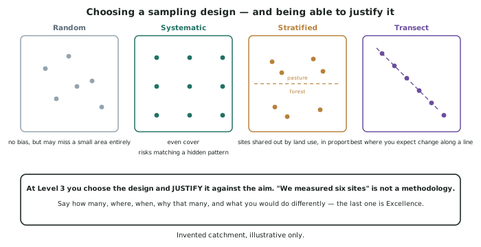
Choosing a sampling design
- Random — sites chosen by chance. No bias, but it may miss a small but important area entirely.
- Systematic — sites at a fixed interval. Even cover, but it can accidentally match a hidden pattern in the landscape.
- Stratified — sites shared out between categories in proportion, such as land use. Good when you already know the categories matter.
- Transect — a line of sites across an expected gradient. Best where you expect change along a line, which is why it suits a river study.
- Say which you used and why. In the invented study the design is a transect, because the aim is about change downstream, and a transect is the design that measures change along a line.
Consultation, and what it means in practice
- You initiate the discussion. Bring your teacher a written aim and a draft method, and ask specific questions about them.
- Good consultation questions are about design: Is five sites enough to show a downstream pattern? Should I sample after rain or avoid it? Is my third site far enough below the land-use boundary?
- Record the consultation. A short note of what you asked, what was suggested and what you changed is evidence of the process the standard names, and it feeds directly into your evaluation.
- Consultation is not approval. You can take advice and decide against it — provided you say why.
- Safety and permission are part of the design: landowner permission, river access, a safety plan, and never sampling alone.
Worked Example
Worked example
A student proposes: "My aim is to see if the Rerenga River is polluted."
Diagnose the aim, then rewrite it, and write the methodology it implies.
Answer:
Step 1 — test the aim against the three requirements.
What will be found out? Polluted is undefined — polluted by what, measured how, and compared with what threshold? Where? The whole river, which is 14 km of study reach and cannot be sampled uniformly. Over what period? Unstated. Spatial component? None — the aim asks a yes/no question about one object, so nothing varies across space and there is nothing geographic to analyse.
Step 2 — rewrite it.
To investigate how nitrate concentration and water clarity in the Rerenga River vary with distance downstream and with adjacent land use, across a 14 km study reach, on four sampling days in March.
Now the aim names the variables, the space, the period, and the comparison — and it can be shown to be answered.
Step 3 — derive the focusing questions.
- How does nitrate concentration change with distance downstream?
- Does the rate of change differ between the forest, pasture and township reaches?
- Is the pattern consistent across all four sampling days?
Step 4 — design the method the aim requires.
- Design: a transect, because the aim is about change along a line.
- Sites: five, at roughly 3 km intervals — one in the forest reach above any farming, two in the pasture reach, one immediately below the township, and one at the river mouth. Five because three land-use reaches need at least one site each, plus a control above and a site below the last input.
- Variables: nitrate (mg/L) by test kit, water clarity by clarity tube, flow by float and tape, and a land-use record for 200 m upstream of each site.
- Timing: 9 am on four days spread across March, at least three days after rain, so that discharge is comparable between days.
- Controls: same equipment, same operator reading the meter, samples taken from the same position at each site (mid-channel, 10 cm depth), photographs at each visit from a fixed point.
Step 5 — the consultation questions to take to the teacher.
Is five sites enough to show a downstream trend? Should site 4 be further below the township outfall to allow mixing? Is excluding wet days a control or a bias?